Joint Australian-US Defence Facility Pine Gap
Note: This page is being reconstructed.
NEW PAGES ADDED BELOW. RT 24 JANUARY 2017
See also
- Pine Gap – recent media coverage
- Resources – Joint Defence Facility Pine Gap
- Pine Gap images gallery
- Table and photokey of antennas at Pine Gap
- Pine Gap – protests
- Possibilities and effects of a nuclear missile attack on Pine Gap
- Desmond Ball, Bill Robinson and Richard Tanter, The Pine Gap Project
NEW PAGE:
Introduction
Pine Gap is perhaps the most important United States intelligence facility outside that country, playing a vital role in the collection of a very wide range of signals intelligence, providing early warning ballistic missile launches, targetting of nuclear weapons, providing battlefield intelligence data for United States armed forces operating in Afghanistan and elsewhere (including previously in Iraq), critically supporting United States and Japanese missile defence, supporting arms control verification, and contributing targetting data to United States drone attacks.
Pine Gap: three surveillance systems
Pine Gap today houses three distinct functions and operational systems. Its original and still principal purpose is to serve as the ground control station for geosynchronous signals intelligence (SIGINT) satellites developed by the U.S. Central Intelligence Agency (CIA); it probably remains the CIA’s most important technical intelligence collection station in the world. There are now 38 satellite dishes/radomes at Pine Gap. Most are still concerned with the core function of controlling geosynchronous SIGINT satellites and processing and analysing the intercepted intelligence.
Secondly, since late 1999 Pine Gap has hosted a Relay Ground Station (RGS), which relays data from U.S. missile launch detection/early warning satellites/Overhead Persistent Infrared (OPIR) – formerly the Defense Support Program (DSP) but now including the Space-Based Infrared System (SBIRS) – to both U.S. and Australian HQs and command centres. Six of the satellite terminals at Pine Gap (four in radomes and two unshielded) belong to the RGS. Another three radomes are probably associated with the U.S. Missile Defense Agency’s Space Tracking and Surveillance System (STSS).
Finally, Pine Gap appears to have acquired a FORNSAT/COMSAT (foreign satellite / communications satellite) interception function in the early 2000s. This was probably presaged with the arrival of Service Cryptological Agency (SCA) elements at the end of the 1990s. Two 23-metre dishes suitable for COMSAT SIGINT Development (Sigdev) were installed inside 30-metre radomes in 1999-2000. A Torus multi-beam antenna was installed at Pine Gap in 2008.
From strategic intelligence to warfighting
When first established by the United States in 1966 (becoming operational by 1970, and in part by early 1969) the original purpose of Pine Gap was to collect information on the testing of Soviet missiles. During missile tests, information on the performance of various parts of the missile in flight is sent by radio signal to the test base. U.S. satellites in geo-stationary orbit sitting above the earth intercepted this missile telemetry, and downlinked the data to Pine Gap and other ground stations. That data was then processed into usable signals intelligence about the performance and capacities of new Soviet missiles. Pine Gap continues this activity today, monitoring the testing of missiles by a wide variety of countries, including North Korea.
However, in the half century since it was first built, Pine Gap and the systems of which it is a part have undergone extraordinary technical development, greatly increasing the sensitivity and breadth of its of its signals intelligence capacities – most notably in the interception of cell phones and satellite communications. This has provided the technical basis for Pine Gap to provide data enabling the targeting of illegal U.S. drone attacks in countries with which the United States nor Australia are at war, including Pakistan, Yemen and Somalia.
There is a second aspect of Pine Gap’s activities, which was never envisaged by the government that allowed its establishment. Following the closure of the U.S. base at Nurrungar in 1999, Pine Gap has hosted a remote ground station for several generations of U.S. early warning satellites. Powerful infrared telescopes on geostationary satellites detect the thermal signature of ballistic missile launches. Today, this technology originally aimed at providing early warning of possible attack on the United States has been extended to contribute to the rapidly evolving U.S. and Japanese missile defence systems on land and sea aimed at defeating a North Korean missile attack. Pine Gap’s role is to downlink the data indicating a probable launch and compute its probable trajectory. These warning calculations are then transmitted to the less powerful but more fine grained missile defence radars in the western Pacific, which then have a realistic chance of locking onto the missile early in its flight and destroying it. Without the “cueing” provided by Pine Gap, this is difficult, if not impossible at the present time, making Pine Gap an integral part of United States ballistic missile defence.
See also:
- Resources – Joint Defence Facility Pine Gap
- Table and photokey of antennas at Pine Gap
- Pine Gap – protests
- Possibilities and effects of a nuclear missile attack on Pine Gap
Pine Gap – ANNOTATED PHOTOKEY (February 2016)
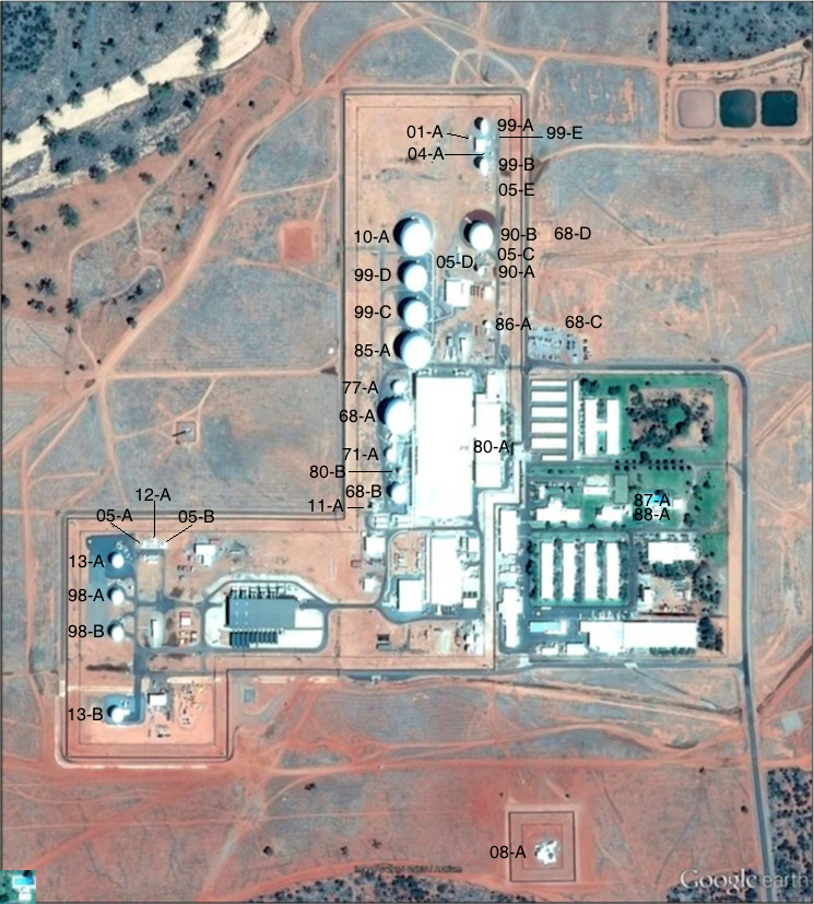
Figure 1. Antenna systems at Pine Gap, Google Earth imagery, 6 November 2015.
Note: for antenna identification system see Desmond Ball, Bill Robinson and Richard Tanter, The Antennas of Pine Gap, Nautilus Institute, Special Reports, February 2016.
SEE ALSO
- Resources – Joint Defence Facility Pine Gap
- Pine Gap images gallery
- Pine Gap – protests
- Possibilities and effects of a nuclear missile attack on Pine Gap
- Australian defence facilities
Project coordinator: Richard Tanter
21 February 2016