Introduction
The Department of Defence has a cluster of communications facilities in the region of Wagga Wagga in the NSW Riverina, including the transmitter and receiver and elements of the Riverina node of the Modernised High Frequency Communications System (MHFCS), described by the local council as “home to some of the most advanced communication technology in the world.”[i] The two facilities, constructed in 2000-2001, separated by about 50 kms, are used by a number of different elements of the Australian Defence Force. For the Australian Defence Signals Directorate (ASD – formerly Defence Signals Directorate), the location of the Morundah Receiving Station means it is a key part of its high frequency communications monitoring and interception capacities directed at foreign military and government targets.
The transmitter facility is at Lyndoch on the Collingully – Lockhart road, 35.6 kms due west of Wagga Wagga.[ii] The receiver facility is on the northern side of the Morundah – Boree Creek Road 15.7 km southeast of Morundah.[iii] Both the transmitter and receiving stations are operated remotely from the Network Management Facility at HMAS Harman Canberra (and a backup at Russell Offices).[iv]

Figure 1. Modernised High Frequency Communications System (MHFCS) Riverina node locations.
Source: Parliamentary Standing Committee on Public Works, Report relating to the proposed Development of buildings and services in support of Department of Defence Joint Project 2043, High Frequency Modernisation Project, Parliament of the Commonwealth of Australia, 1997.
1. The Lyndoch transmitter and Local Management Facility: Collingully Defence Communications Station – Transmitter (DEFCOMMSTA).
The Defence Department operates a high frequency transmitter facility on the Collingully – Lockhart road, 35.6 kms due west of Wagga Wagga at coordinates 35° 7′ 31.79″S, 146° 58′ 44.58″ E.[v] The site is locally known as Lyndoch, after the name of the homestead on whose land it is built. The address is 51 Lockhart Road, Brookdale, NSW 2656. “Lyndoch” is the name of a Defence Department property of 2,092 ha.[vi] formerly owned by the Bruckner family[vii], now leased back to the family in conjunction with its Defence use. Various names for the facility appear, including “Collingully Defence Communications Station – Transmitter (DEFCOMMSTA).[viii]
The HF transmitter consists of a main circular antenna array made up of two concentric rings of masts, with ten smaller antennas outside the circles. The outer ring is 500 m. in diameter, with 18 pairs of masts. The inner ring is 365 m. in diameter, and is made up of 20 single masts. (Figure 2)
Surrounding the two core circles are ten separate sets of antennas: three sets with four masts, three log periodic antennas, and two sets of pairs of two masts, and two rosette antennas with single masts. (Table 1 and Figures 2- 5, and Table 1).
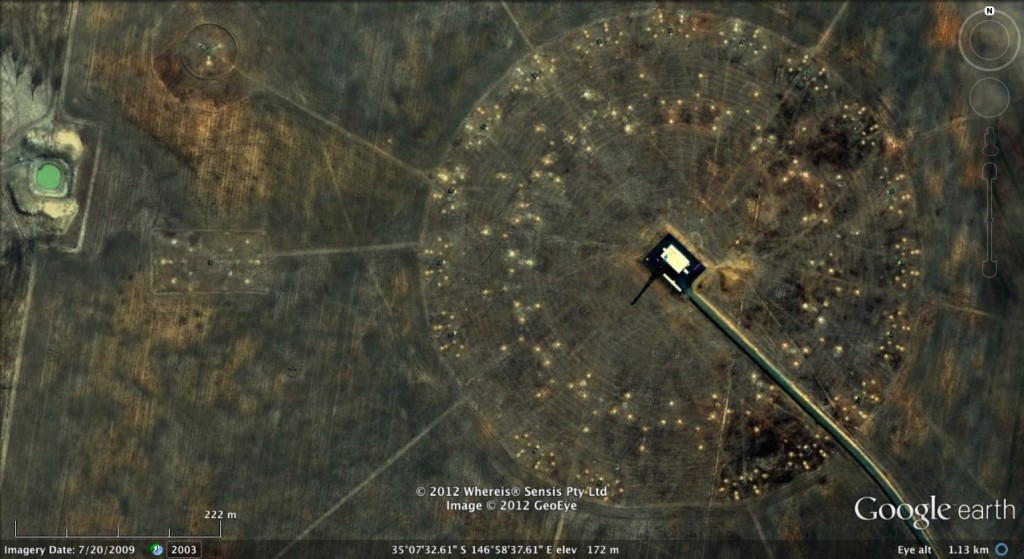
Figure 2: Lyndoch transmitter and Local Management Facility: Collingully Defence Communications Station, Google Earth 20 July 2009.
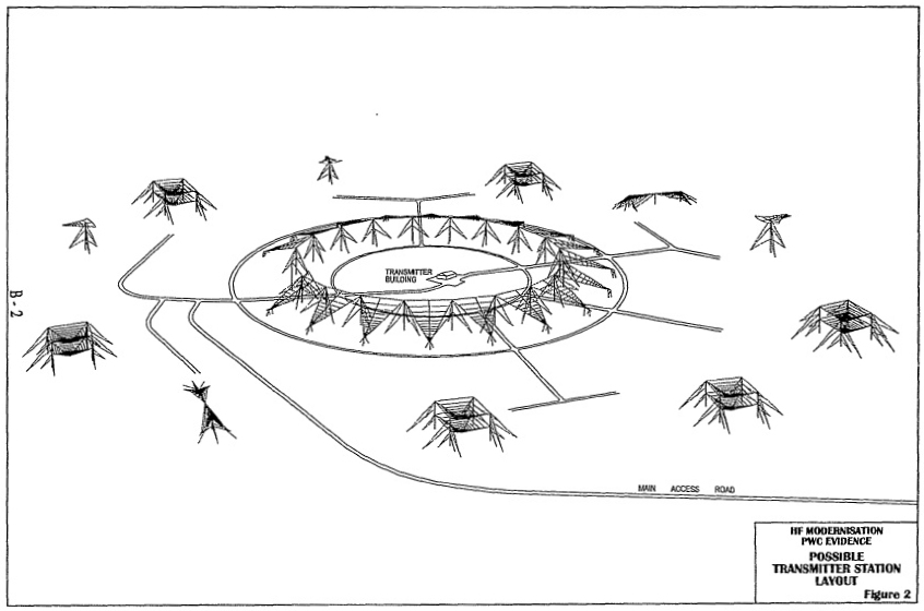
Figure 3: Transmitter station schematic proposed layout, 1997.
Source: Parliamentary Standing Committee on Public Works, Report relating to the proposed Development of buildings and services in support of Department of Defence Joint Project 2043, High Frequency Modernisation Project, Parliament of the Commonwealth of Australia, 1997.
There are ten antennas sets outside the two circles of antennas, located between 550 and 650 meters from the centre of the circles. This disposition is the same in terms of type, number and position as those outside the central area of the Humpty Doo Transmitter Station, and very similar in terms of sizes.[ix] It is also very similar to the organization of the North West Cape Transmitter Station.[x]
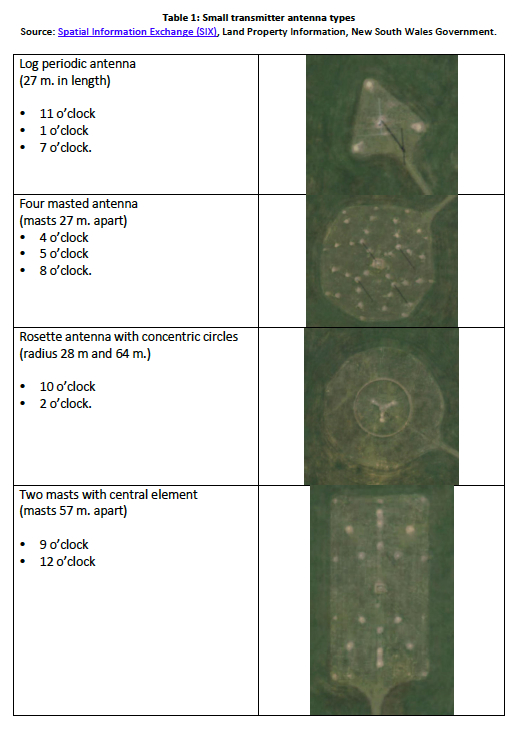
Table 1: Small transmitter antenna types
Source: Spatial Information Exchange (SIX), Land Property Information New South Wales Government.
Source: “Modernised High Frequency Communications System enters service”, Velocity, Boeing Australia & South Pacific, October 2009
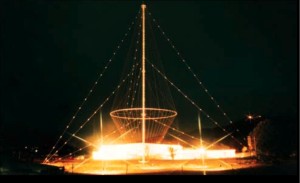
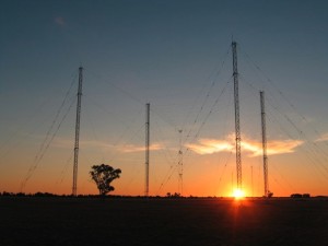
Figure 5: Rosette antenna
Source: Fiona Tristram, “Back to the future: Boeing team in Australia develops advanced communications system using ‘old’ technology”, Boeing Frontiers, December 2009–January 2010, p. 33.
2. Morundah Defence Communication Station – Receiver
This facility is 19 ha. in size, located on a 12, 760 ha. property at 146° 24′ 42.20″ E , 35° 1′ 33.26″ S, on the northern side of the Morundah – Boree Creek Road 15.7 km southeast of Morundah.[xi] It consists of a single story building with a tower supporting two microwave dishes, surrounded by an antenna farm of masts (Figures 6, 7, and 8).
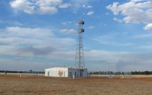
Figure 7: Receiver Site building at Morundah
Source: JP 2043 – High Frequency Modernisation Project, Defence Materiel Organisation.
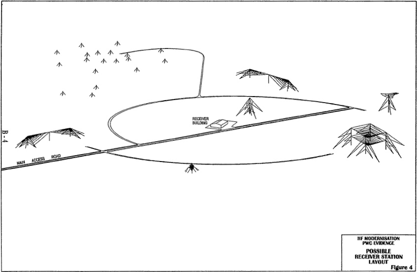
Receiver station schematic proposed layout, 1997.
Source: Source: Parliamentary Standing Committee on Public Works, Report relating to the proposed Development of buildings and services in support of Department of Defence Joint Project 2043, High Frequency Modernisation Project, Parliament of the Commonwealth of Australia, 1997.
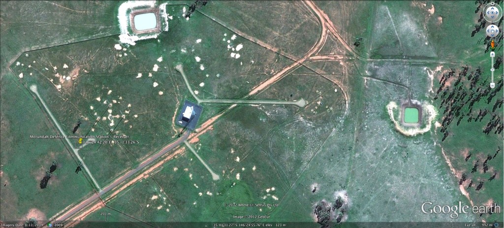
Figure 8: Morundah Receiving Station.
Source: Google Earth, July 2009
3. Management, linkage, and operation
The Riverina node, like the other three MHFCS base stations are remotely operated from HMAS Harman (and a secondary control centre in Canberra). A Local Management Facility “provides a secure environment for the management and control of communications passing through that node.”[xii] In early plans, the Riverina node LMF was to have been located within the communications centre of RAAF Base Wagga, but was subsequently co-located with the Collingully Transmitter Station at Lyndoch.[xiii]
Following the closure of the Bonshaw Receiving Station at HMAS Harman, Defence Signals Directorate (now ASD) use the Morundah MHFCS Receiving Station for high frequency communications monitoring and interception, and high frequency direction finding (HFDF) – see below.
The Riverina node is linked to the Canberra Network Centre, and to the other three base nodes by optical fibre, and the elements of the node are linked by optical fibre and/or microwave.[xiv] In July 2000, a contract worth more half a million dollars was announced for a fibre cable internode link between Lyndoch and the very small town of Bulgary 11 kms to the north of the CDAA.[xv]
4. High frequency direction-finding capacity
In 1994, the original MHFCS Operational Requirement and Capability Baseline indicated that the system
“was required to support High Frequency Direction Finding for search and rescue, electronic counter counter measures and frequency management. The system was to achieve this by having dedicated equipment at each of the four Nodes able to locate emitters within the area of coverage of the communication system.” [xvi]
In 2000 the Defence Department expressed dissatisfaction with the capacities of the HFDF facility proposed by Boeing as Prime Contractor for the MHFCS, and two years later the HFDF capacity requirement was withdrawn from the Boeing contract.
Subsequently identified as Project Nullarbor, prototype development and evaluation of an HFDF capacity was completed in 2004 as Project Nullarbor Phase 1, involving Communications Systems Engineering & Management Pty Ltd.[xvii] Tenders for Phase 4 for installation and support at the four node receiver sites and in Canberra network centre and its back-up were called for and closed in late 2011.[xviii]
[i] Wagga Wagga City Council submission to the 2008 Defence White Paper, 3 October 2008.
[ii] Defence Communications Project Progress, Media Release, Department of Defence, PACC 112/00, 6 June 2000.
[iii] Glenn Hauser (ed.), DX Listening Digest 4-044, 9 March 2004.
[iv] Defence Communications Project Progress, Media release, Department of Defence, PACC 112/00, 6 June 2000; and The Auditor-General, Performance Audit: High Frequency Communication System Modernisation Project, Department of Defence, Defence Materiel Organisation, Audit Report No. 34, 2006–07, para 1.19.
[v] Latitude -35.125587, Longitude 146.979035.
[vi] See New South Wales Spatial Data Catalogue.
[vii] Conversation with local informant [Mr Percy Jones, Cross Roads Hotel, Collingullie], 18 December 2012.
[viii] House of Representatives Notice Paper Question No 2094.
[ix] See DSD – Humpty Doo Transmitter Station, Draft: 22 January 2013.
[x] See DSD – Northwest Cape HF transmit site, Draft: 22 February 2013.
[xi] Latitude -35.025560°, Longitude 146.414931°.
[xii] Parliamentary Standing Committee on Public Works, Report relating to the proposed Development of buildings and services in support of Department of Defence Joint Project 2043, High Frequency Modernisation Project, Parliament of the Commonwealth of Australia, 1997.
[xiii] Parliamentary Standing Committee on Public Works, Report relating to the proposed Development of buildings and services in support of Department of Defence Joint Project 2043, High Frequency Modernisation Project, Parliament of the Commonwealth of Australia, 1997; and Defence Communications Project Progress, Media Release, Department of Defence, PACC 112/00, 6 June 2000.
[xiv] Parliamentary Standing Committee on Public Works, Report relating to the proposed Development of buildings and services in support of Department of Defence Joint Project 2043, High Frequency Modernisation Project, Parliament of the Commonwealth of Australia, 1997, para 22.
[xv] Cable Works Pty Ltd. received a contract worth $552,158.20 for “Internode links: fibre cable Lyndoch to Bulary route For HFMOD Project”. See Contracts Gazetted from 1 July 2000 – 30 June 2001, Valued at $100,000 and Above, Department of Defence.
[xvi] The Auditor-General, Performance Audit: High Frequency Communication System Modernisation Project, Department of Defence, Defence Materiel Organisation, Audit Report No. 34, 2006–07, paras 3.7 – 3.10, and 3.38.
[xvii] Sometimes also known as “Sub-project Nullarbor”. See “Project Nullarbor”, Communications Systems Engineering & Management Pty Ltd.See also John Caruana, “New Service Developments at IPS Radio and Space Services”, IPS Radio and Space Services, Ionospheric Prediction Service, Radio and Space Services, Bureau of Meteorology.
[xviii] AusTender, High Frequency Direction Finding and Signal Improvement, Defence Materiel Organisation – Electronic Systems Division, close 12 December 2011.
Project coordinator: Richard Tanter
Updated: 24 November 2013