Under construction. Last updated: 24 August 2025
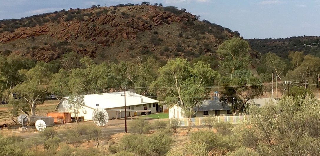
Joint Geological and Geophysical Research Station (October 2018), Schwarz Ave, Alice Springs.
Source: courtesy Alice Springs News
AFTAC Detachment 421 wall mural, JGGRS .
Source: ‘Det 421 Rec Center‘, Facebook, [accessed 23 August 2025]
Contents
- Introduction
- Location
- The JGGRS seismic array
- AFTAC
- JGGRS, arms control verification and strategic role
- Appendix: Australian budget allocations for the JGGRS, 2009-2015
Introduction
‘Australia is not only a beneficiary of the US policy of extended nuclear deterrence, it is an active supporter of it, through our joint efforts with the US at Pine Gap and at other facilities, such as the Naval Communications Station Harold E. Holt, and the Joint Geological and Geophysical Research Station.’
Christopher Pyne, Minister for Defence, 20 February 2019
Joint Geological and Geophysical Research Station 2018 (courtesy of Alice Springs News)
Location:
Coordinates: 23.698°S 133.882°E
Address: Schwarz Crescent, Alice Springs
See also: ‘Joint Geological and Geophysical Research Station’, Wikipedia, [accessed 24 August 2025]
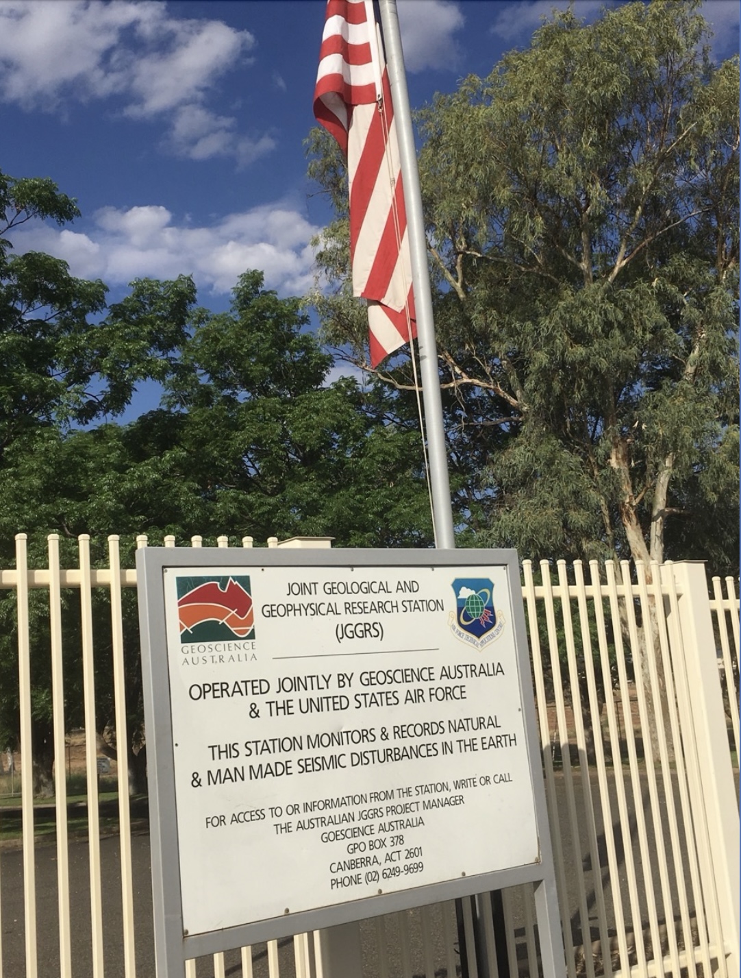
The Joint Geological and Geophysical Research Station (JGGRS) is a seismic detection and monitoring station at Alice Springs in Central Australia. The station was established in great secrecy in 1955 by the US Air Force to detect the seismic indicators of nuclear test detonations, and to assist the U.S. to assess Soviet nuclear design developments, and inform its own nuclear planning in response. the Alice Springs seismic monitoring station is the oldest permanent United States military facility in Australia. For much of its life, the station was officially described as merely a weather station, and the Australian parliament was not informed of its true purpose – to monitor nuclear explosions – until 1973.
Under an agreement signed the Fraser coalition government with the USAF in 1978, the facility redesignated the Joint Geological and Geophysical Research Station. The 1978 Exchange of Notes specified that
‘The purpose of the Station is to gather seismic data. The seismic data from this Station will aid in monitoring compliance with agreements on underground nuclear explosions and, when combined with data from other Australian stations, will also provide useful information on the geology of Australia.’
Since its establishment in 1955, the Alice Springs seismic station has been operated by secretive Air Force Technical Applications Agency (AFTAC) through AFTAC’s Alice Springs-based Detachment 421, 709th Technical Maintenance Squadron. AFTAC is now part of the USAF 16th Air Force (Cyber). AFTAC operates the United States Atomic Energy Detection Systems (USAEDS), a global nuclear detonation system made up of more than 3,600 sensors worldwide. This system consists of seismic monitoring stations like the JGGRS which are particularly effective at detecting underground explosions, infrasound sensors to detect atmospheric pressure changes, hydroacoustic microphones to detect underwater detonations, airborne radionuclide detectors, and space-based optical, radio-frequency, and radiation detection technologies mounted on Global Positioning System (GPS) and Defense Support Program (DSP) satellites – the latter downlinking through the Joint Defence Facility Pine Gap. USEADS nuclear detonation data and analysis is immediately transmitted to Space Command through the Integrated Tactical Warning/Attack Assessment (ITW/AA) system.
Source: Phenomenology of nuclear explosions, from the subsurface to outer space.
Source: National Academies of Sciences, Engineering, and Medicine 2021. Nuclear
Proliferation and Arms Control Monitoring, Detection, and Verification: A
National Security Priority: Interim Report. Washington, DC: The National
Academies Press. https://doi.org/10.17226/26088.
For the four decades since the Alice Springs seismic station was re-branded as a joint U.S.-Australian facility, Australian government agencies (now Geoscience Australia) have nominally managed the station together with AFTAC Det. 421.
‘The purpose of the Station is to gather seismic data. The seismic data from this Station will aid in monitoring compliance with agreements on underground nuclear explosions and, when combined with data from other Australian stations, will also provide useful information on the geology of Australia.’
In fact, Geoscience Australia appears to have no role in operations at the seismic station, and provides no capital or operating budget, and has no permanent staff onsite. While Australia has the right to locate staff at the station, the facility is in practice run entirely by the the USAF AFTAC. In 2016 Detachment 421 had a staff of five, including an Air Force major, a master sergeant, a technical sergeant, and a senior airman.
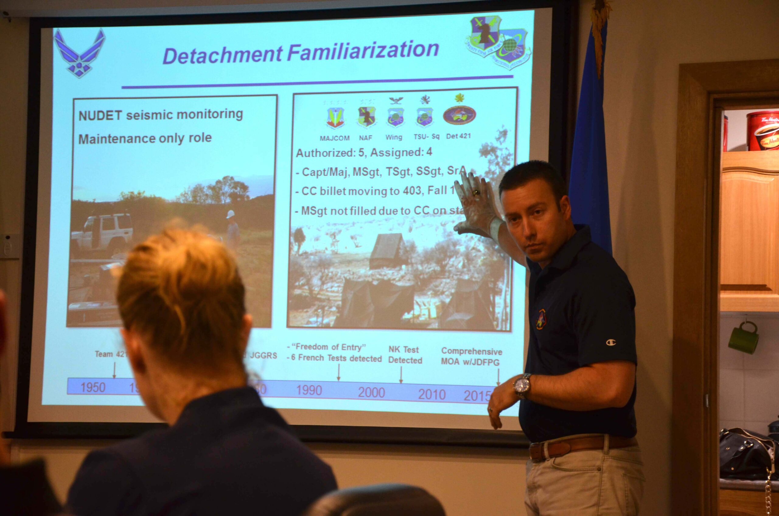
Briefing by Major Jesse Foster, Commander AFTAC Detachment 421, 16 December 2015. Source: USAF, Air Combat Command, VIRIN: 151216-F-SR919-001
Seismic data from the Alice Springs seismic detection network goes in real-time to AFTAC headquarters at Patrick AFB in Florida, to Geoscience Australia, and to the International Monitory System (IMS) of the Comprehensive Test Ban Treaty Organisation (CTBTO) in Vienna. As a signatory to the CTBT, Australia is required to maintain the JGGRS, which is identified in the treaty annex as Primary Seismic Station 03 (PS03). All seismic monitoring data from JGGRS passed in ‘close to real time’ to
- the CTBTO International Monitoring System in Vienna;
- GeoScience Australia in Canberra;
- U.S. National Data Center at AFTAC HQ at Patrick AFB which collates data from the U.S. Atomic Energy Detection Systems (USAEDS).
From the signing of the Partial Test Ban Treaty in 1962, the seismic data the Det 421 station fed into the United States Atomic Energy Detection System (USAEDS) Network contributed to the US capability to verify Soviet compliance with the treaty. Since XXXX the JGGRS has contributed seismic data to the International Monitory System (IMS) of the Comprehensive Test Ban Treaty Organisation (CTBTO). Unlike USEADS, the IMS does not have space-based sensors.
The JGGRS seismic array
The original and still primary role of the facility and its array of seismic sensors just outside Alice Springs is to monitor the seismic signals of nuclear explosions at very great distances through the body of the earth – teleseismic signals. Nuclear explosions have seismic characteristics that enable them to be distinguished from earthquakes and other humanly-generated seismic events. Originally the only AFTAC facility in the Southern Hemisphere, JGGRS data only revealed its full potential when combined with seismic signals monitored elsewhere on the earth’s surface.
The JGGRS is one of seven Australian seismic stations contributing to the Comprehensive Test Ban Treaty (CTBTO) International Monitoring System.
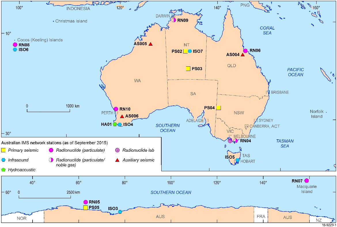
GeoScience Australia IMS nuclear detonation sensors system (2018)
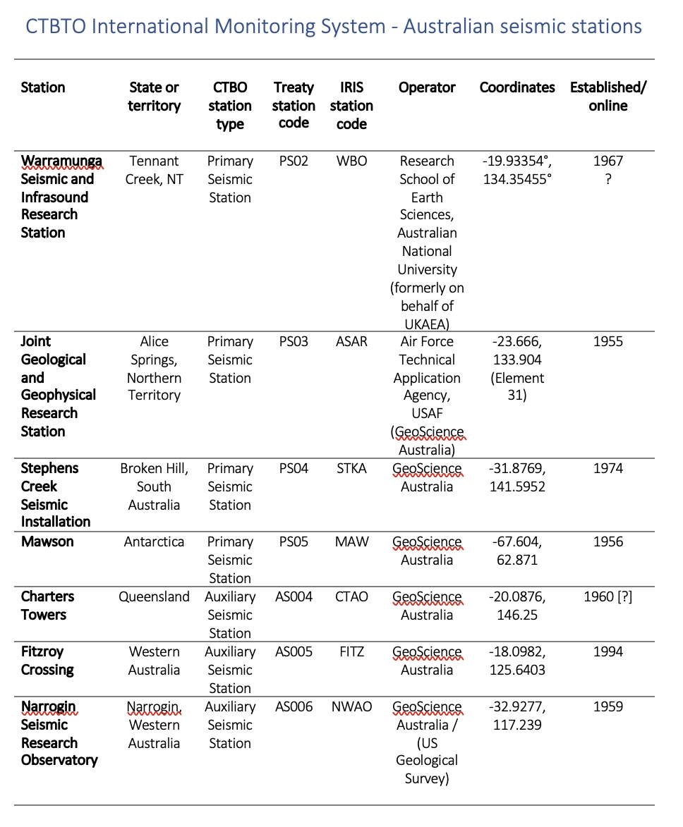
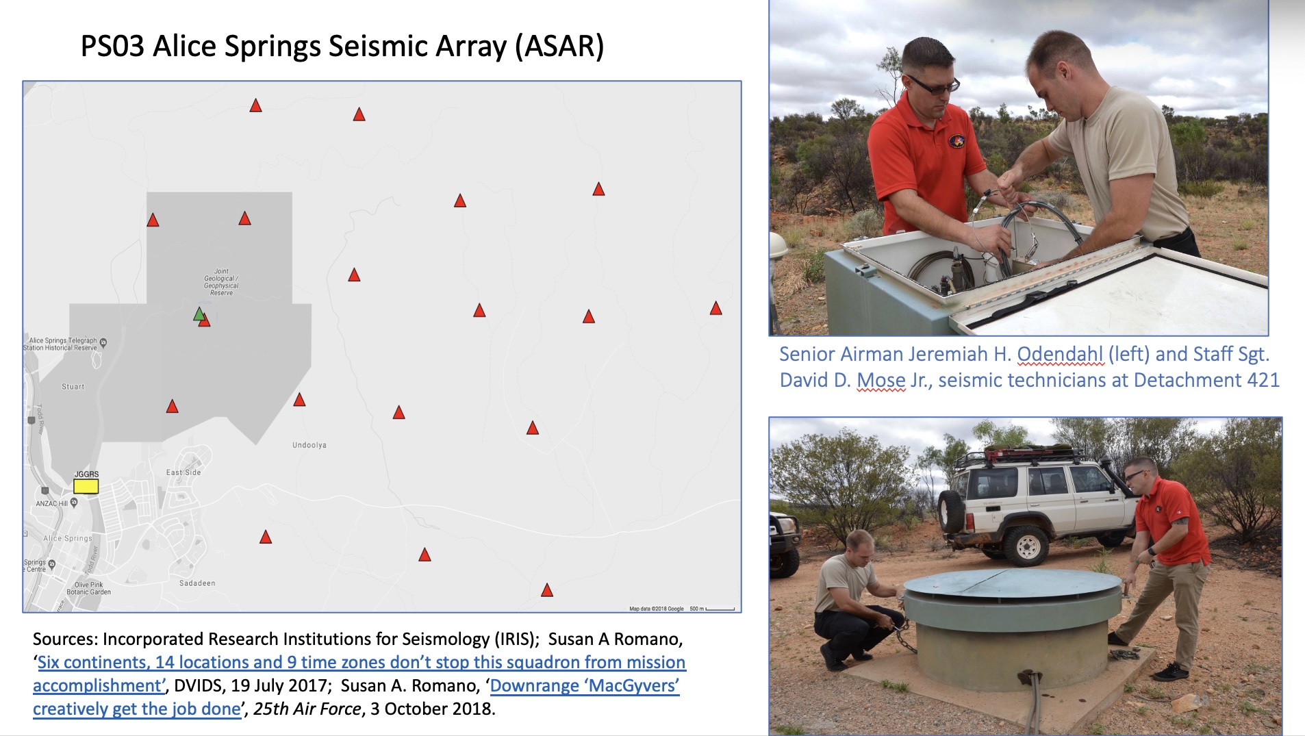
The JGGRS seismic array is made up of 19 broadband seismometers, one 3-component short-period seismometer, and one 3-component long-period seismometer, located in subsurface concrete containers. Most of these sensors are spread over 80-100 sq. kms to the north and east and the JGGRS building site. AFTAC Det. 421 technical personnel charged with maintaining the sensor array consider the facility’s location far from major population centres and industrial activity, coupled with its geological characteristics, to be optimal for telesismic sensing:
‘n Alice Springs the bedrock is really close to the surface of the Earth. We don’t have to dig that deep to get into solid bedrock and having that acts as a giant microphone for everything going on in the earth. It gives us high fidelity on what we are seeing underground.’
See: ‘Seismic Activity‘, Defense.gov, 4 June 2020
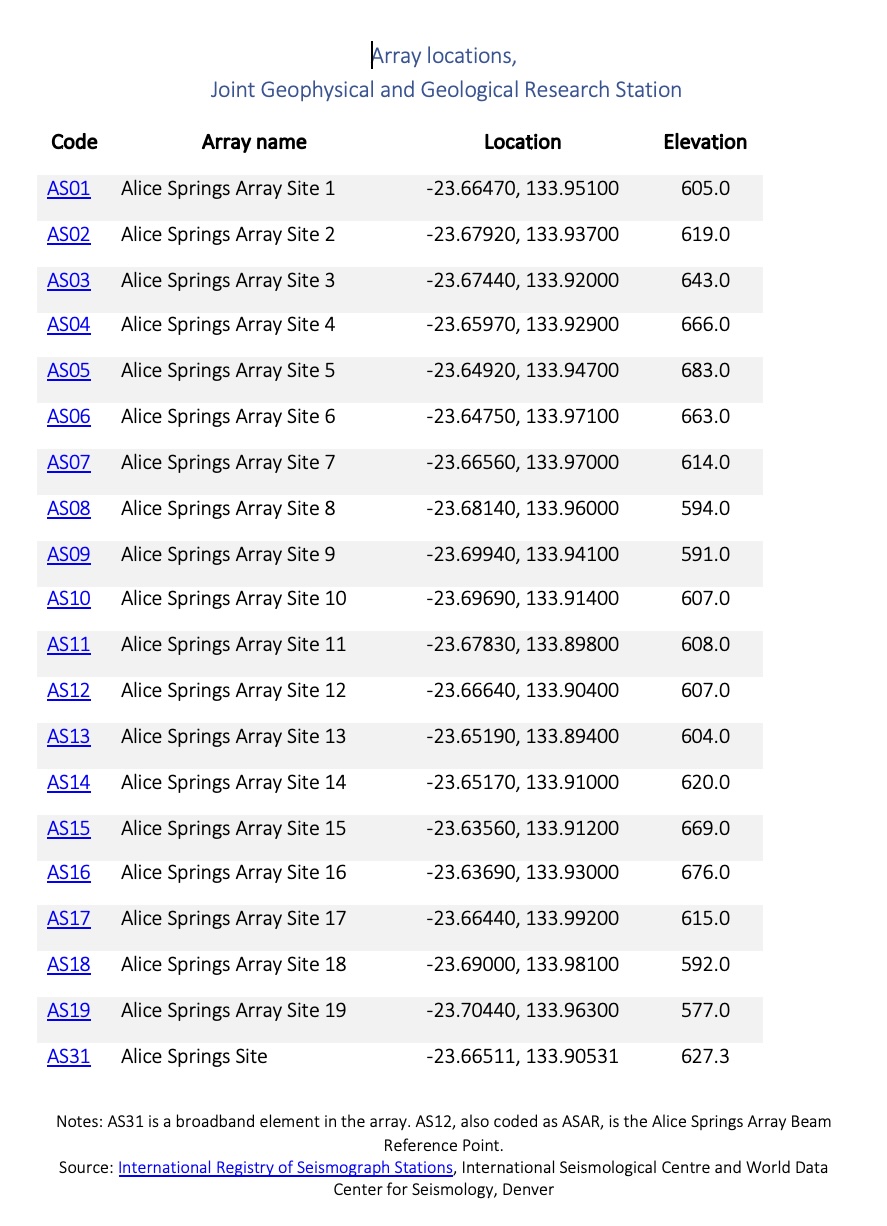
JGGRS seismic array locations.
Source: International Registry of Seismograph Stations, International Seismological Centre and World Data Center for Seismology, Denver
AFTAC
In May 2025, the commander of the U.S 16th Air Force (Cyber), Lt. Gen. Thomas K. Hensley, visited AFTAC headquarters to commend the unit’s ‘vital no-fail mission’ in nuclear surveillance:
‘In today’s world, one of our nation’s biggest threat – the Chinese Communist Party – is a lethal, modernized nation-state that is expanding every day. It’s of the utmost importance for the United States to deter that threat, and AFTAC plays a crucial role in that deterrence.
‘The AFTAC at War concept really gets after the DOD’s warrior ethos priority by operationalizing science and technology to enhance battlespace characterization. This organization is like no other in the world, and the President and Secretary of Defense are relying on AFTAC to support their initiatives, especially the Golden Dome defense shield.’
JGGRS, arms control verification and strategic role
- ‘Annex D: The Oak Tree Notes. Exchange of notes between Australia and the United States constituting an agreement on Detachment 421’, in Desmond Ball, A Suitable Piece of Real Estate: American Installations in Australia, (Hale & Iremonger, 1980), pp. 171-2.
- Exchange of Notes constituting an Agreement between the Government of Australia and the Government of the United States of America regarding the Management and Operation of the Joint Geological and Geophysical Research Station at Alice Springs, (Canberra, 28 February 1978), Australian Treaty Series 1978 No 3, at https://www.austlii.edu.au/au/
other/dfat/treaties/ATS/1978/ 3.html.
Source: Jennifer Schneider, ‘New nuclear-monitoring facility generates positive reaction’, Air Force Civil Engineer Center, 17 April 2014
Built in 1955, the Alice Springs seismic monitoring station is the oldest permanent United States military facility in Australia. For much of its life, the station was officially described as merely a weather station, and the Australian parliament was not informed of its true purpose – to monitor nuclear explosions – until 1973. This deception of the Australian public was a matter of official Australian policy from the beginning, with a government press release on 10 April 1955 stating that
‘The joint RAAF and USAF station at Alice Springs is conducting weather research in the Southern Hemisphere to provide correlation with the results now completed in the Northern Hemisphere.’ [1]
At the time, official deception activities extended to emplacing a small number of RAAF personnel in Alice Springs ‘during the construction and preliminary operation of the station’ in order ‘to give an impression of a joint effort’. [2] In fact, there have never been permanent Australian staff, military or civilian, at the station.
Since 1956 the Alice Springs seismic station has been an important element in the United States Atomic Energy Detection System (USAEDS), and remains so today – in part because for a long time it was the only station in the southern hemisphere.[i] Great secrecy surrounded the facility’s purpose and capabilities through the 1950s and 1960s until 1973 when the Whitlam government made its actual purpose public, calling it by its current ‘joint’ name for the first time.[ii]
From the signing of the Partial Test Ban Treaty in 1962, the seismic data the station fed into the United States Atomic Energy Detection System (USAEDS) global network of sensors contributed to the US capability to verify Soviet compliance with the treaty. Since 1996 the JGGRS has contributed seismic data to the International Monitory System (IMS) of the Comprehensive Test Ban Treaty Organisation (CTBTO).
The contribution by the JGGRS to arms control verification has been highlighted by the Australian and United States governments as far back as 1980, and continues to be repeated in both US and Australian accounts of the station today. There is no doubt that the global seismic monitoring system under the CTBTO’s International Monitoring System is effective and reliable in detecting, locating, measuring and characterizing nuclear detonations, especially underground, worldwide, at least down to extremely small explosive yields. The JGGRS is an important element in that enterprise.
Yet as far back as 1980, in his pathbreaking 1980 book A Suitable Piece of Real Estate, Desmond Ball noted that the ‘real reasons for the secrecy attaching to the small station had ‘nothing to do with arms control’.
The first of these unstated reasons for secrecy was that the seismic data from the station helped to understand the characteristics of adversary nuclear weapons programs ‘in order to determine what countermeasures the US should deploy in its strategic forces.’
The second, wrote Ball, is that ‘the US uses the data for its own nuclear weapons development: it is a relatively cheap way of supplementing data derived from its own tests’. [Ball,1980, pp. 86-87]
The situation today is that the JGGRS continues to have all three of these roles. The JGGRS contributes to the public good of the CTBTO monitoring system – and to the Australian seismic monitoring system. It enables US detection and characterization of adversary nuclear weapons systems, assisting the U.S. to better develop and deploy its own nuclear weapons.
Were Australia to sign and ratify the Treaty on the Prohibition of Nuclear Weapons, the second and third roles of the JGGRS would be violations of Australia’s treaty obligations. On the other hand, these may be balanced against the public good of the station’s involvement in the CTBO monitoring system. Indeed, the capabilities of that system will be one foundation of a post-abolition verification system, and on that basis, an argument for the retention of the facility could be made.
However, while the Alice Springs array makes a useful contribution to the IMS, it is by no means irreplaceable. Indeed, at least two other seismic arrays in central and northern Australia contributing to the IMS are capable and sensitive as the Alice Springs array, capable of replicating detections by it.
Little would be lost to Australian seismic monitoring capabilities for either CTBTO purposes or national seismic monitoring requirements if it was replaced by a single seismograph owned and operated by Australia. This would suggest that on balance, since the station is a U.S. Air Force-built and -operated facility without Australian participation that contributes to U.S. nuclear war deployment planning and nuclear weapons development that would put Australia in violation of the treaty, it should be closed if Australia is to become treaty compliant.
The JGGRS was and is attractive to the United States both scientifically and politically. Located in the geologically stable centre of a large continent distant from the noise of ocean waves, and in a region without frequent high winds. As the success of the initial cover story about a weather station suggests, there is little political difficulty about the station.
Early history
The Alice Springs seismic station has its origins in the earliest days of the Cold War, when its parent organisation, now the Air Force Technical Applications Agency (AFTAC), was established in late 1947 as the Long Range Detection Division, Special Weapons Group, and the following year as the Air Force Office of Atomic Energy, Section 1 (AFOAT-1). As the group’s original name suggested, ‘the heart of the mission’ was to solve a problem facing the United States: how to detect and identify nuclear explosions, primarily from a distance. As the AFTAC commemorative history emphasized,
‘Since the United States was the only country to possess such a device during the ’40s no foundation for developing detection methods existed…The research and development efforts required to reach the original goal were phenomenal.’ [3]
Within a year, AFOAT-1 had established the first elements of what was to become the highly classified Atomic Energy Detection System (AEDS), bringing its first great success when its airborne and ground radiological monitoring teams detected the first Soviet atomic explosion that took place on 29 August 1949. [4] The organisation’s credibility grew rapidly, and ‘the original goals and mission concepts were expanded and given a “green light’. [5]
AFOAT-1’s network of seismic monitoring of nuclear explosions began with in Alaska in late 1949. A need for seismic monitoring locations abroad was driven by concerns about a Soviet drive for a hydrogen bomb. By the Soviet Union exploded its first thermonuclear weapon at Semipalatinsk on 22 November 1955, the AEDS seismic network outside the United States included stations in Turkey (AFOAT-1 Team 301), Germany (Team 313A), Denmark (Greenland: Team 220), South Korea (mobile), and Australia.
In March 1954, the Deputy Chief of AFOAT-1, Air Force Colonel Jack Gibbs, sought guidance on setting up a seismic installation in Australia from the Special Assistant to the Secretary of State for Atomic Energy Affairs, Gordon Arneson, often known as ‘State’s Mr. Atom’ for the knowledge of nuclear weapons issues he had developed since his work as secretary to the Interim Committee on Atomic Energy in mid-1945. [6] Arneson took the matter in hand, arranging for a briefing of the U.S. ambassador in Canberra, and setting out the line of approach. Arneson recognized the salience of lingering imperial ties between Britain and Australia, and recommended notifying the British embassy in Washington himself. Given the fact that the British were testing their own atomic weapons in Australia at the time, he proposed
‘to stress that the seismic installation in question is directed solely toward the Soviet Union and that the equipment involved would not be suitable for monitoring of any future British tests that might take place on or near the continent of Australia.’
However, reflecting both the lingering chilliness of the nuclear relationship between the US and the UK after the McMahon Act and an American desire to remind the British of their lowered status in world politics, Arneson signalled a tough line with the British embassy on US activities in their former colony, proposing
‘taking the line that this is for their information only and assuming further that they will be in hearty accord with this project. I would also propose to suggest that we would expect the United Kingdom, should any inquiries be put to them by the Australian authorities, to indicate that they have been informed of our intentions and are of course in accord.’ [7]
On 1 July, Arneson’s plan bore fruit with a meeting of representatives of the Department of External Affairs, Prime Minister’s Department, Department of Defence, Department of Air, United States Embassy and the U.S. Air Force. Following up, the Scientific Assistant to the Defence Science Advisor explained the US proposal in a Top Secret document:
‘The permanent seismic installation which it is proposed to establish in Australia would consist of a line of four instrument vaults spaced at intervals of approximately 2½ miles, and connected by land-line to a recording building which might be up to 15 or 20 miles from the line of instrument vaults. Instrument vaults, which would be about 10 feet square and sunk into the ground, would not normally be manned but would need to be visited for maintenance. The whole installation would be manned by approximately two officers and ten airman. The cost of the installation is estimated at approximately $100,000 (US), exclusive of any power supplies and living accommodation that may be necessary… Construction of the permanent installation might be expected to take some 8 months.’ [8]
Following approval in a Cabinet decision in May 1955, an exchange of notes between Australia and the United States constituting an 10 year agreement with an option for renewal was conducted in June and August, setting a limit of 20 personnel of all ranks and all costs to be borne by the United States. The US embassy’s note in reply acknowledged the Australian ‘expressed hope’ that ‘arrangements could be made for it to obtain the release to some information on the overall results of the operation of the detection system’, and stated that a copy of a national Intelligence estimate on Soviet capabilities in part based directly on the results of the system of which the Australian station is to be part’ had been forwarded to the Australian Embassy in Washington’. [9] For a decade this was to epitomize the practical limit of Australian participation in the operations AFTAC’s Detachment 421 at the Alice Springs station.
Notes:
[1] NAA Series A703, Item 560/1/6 part 2, cited in Spencer Hill Seismic Vault and Array, Heritage Assessment Report, Northern Territory Government Department of natural Resources, Environment and the Arts, 2009, p.7.
[2] NAA Series AA987, Item E1012, cited in Spencer Hill Seismic Vault and Array, Heritage Assessment Report, Northern Territory Government Department of natural Resources, Environment and the Arts, 2009, p. 8.
[3] Mary Welch (AFTAC Inspector-General), ‘AFTAC Celebrates 50 Years of Long Range Detection’, AFTAC Monitor, October 1997, p.10, at https://web.archive.org/web/20110717073938/http://www.foia.af.mil/shared/media/document/AFD-081007-010.pdf
[4] Jeffrey T. Richelson, Spying on the Bomb: American Nuclear intelligence from Nazi Germany to Iran and North Korea, W.W .Norton & Company, 2007, pp. 88-94.
[5] Mary Welch (AFTAC Inspector-General), ‘AFTAC Celebrates 50 Years of Long Range Detection’, AFTAC Monitor, October 1997, p.11.
[6] Jeffrey T. Richelson, Spying on the Bomb: American Nuclear intelligence from Nazi Germany to Iran and North Korea, W.W .Norton & Company, 2007, p. 111; and Neil M. Johnson, Oral History Interview with R. Gordon Arneson, Harry S. Truman Library, 21 June 1989, at https://www.trumanlibrary.org/oralhist/arneson.htm
[7] R. Gordon Arneson, Memorandum for Col. Jack A. Gibbs, U.S. Air Force, Deputy Chief, AFOAT-1, Office for Atomic Energy, DCS/O, 26 March 1954.
[8] NAA Series A5954, Item 1448/4, cited in Spencer Hill Seismic Vault and Array, Heritage Assessment Report, Northern Territory Government Department of natural Resources, Environment and the Arts, 2009, p.5.
[9] Annex D. The Oak Tree Notes: Exchange of notes between Australia and the United States constituting an agreement on Detachment 421’, in Desmond Ball, A Suitable Piece of Real Estate: American Installations in Australia, Hale & Iremonger, 1980, pp.171-172.
Appendix: Australian budget allocations for the JGGRS, 2009-2015
Under the 1978 agreement the Australian government agreed to provide ‘administrative support for the facility’.[1] Between then and 2014-15, Australian funding for the JGGRS has been conducted through a succession of Commonwealth government agencies: between 1978 and 1992 through the Bureau of Mineral Resources (BMR); between 1992 and 1999 through BMR’s successor the Australian Geological Survey Organisation; and from 2001 to at least 2014-15 through GeoScience Australia.[2] For the period for which documentation is available, that Australian funding has been both minimal and entirely without influence on the uses to which the funding was put.
Between 1999 and 2009 Australian contributions towards the administrative costs of the JGGRS had been made through the Australian Geological Survey Organisation Account (AGSO Account), established under the Financial Management and Accountability Act 1997, amended in 1999. In its final year, the AGSO held a balance of $120,000. It is not clear what proportion of the AGSO Account was dedicated to the operation of the JGGRS.
However, in 2009 the AGSO was replaced by a new special account specifically directed to the JGGRS titled the Joint Australian U.S. Geological and Geophysical Research Station Special Account. The JGGRS Special Account was established for Geoscience Australia by order of the Minister for Finance and Deregulation in order to ‘manage funds used to pay the operating costs’ of the JGGRS, based on the 1978 agreement under which the Australian government agreed to provide ‘administrative support for the facility’.[3] In each of the four years the JRRS Special Account functioned before it was closed in 2014-15, Geoscience Australia received $282,000 to pay for its contribution to the cost of operating the JGGRS.
Australian budget funding for JGGRS, 2009-2015
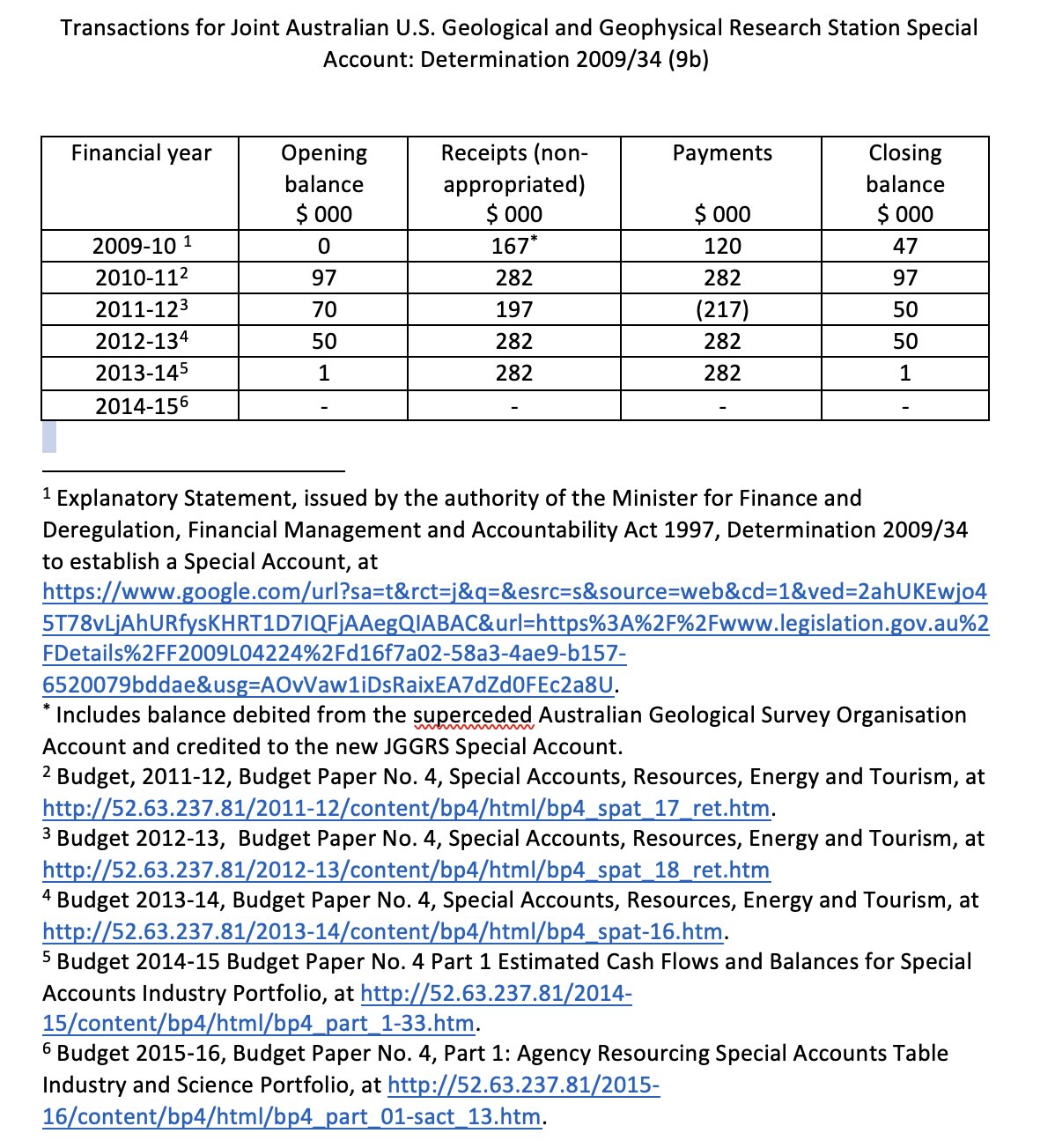
These funds, addressing Australian ‘administrative costs’, would have only been a small proportion of the actual operating costs of the facility. In fact, as the establishing document for the Geoscience Australia special account stated, operating and capital costs for the station
‘are wholly met by the United States Air Force, which decides how all funds are spent. Geoscience Australia has custody and access to the funds but only to arrange disbursement in its capacity of providing administrative support.’
Not only is the size of the Australian contribution derisory, but the government’s own legislative documents make clear that it has long accepted that it has no control over either the activities or the personnel at the station. This places Australia as the nominal auspicing authority in a uniquely complaisant situation when placed alongside the robust and successful indigenization history of former AFTAC-operated USEADS seismic facilities in Spain, Turkey, Thailand and South Korea.
[1] Under the Financial Management and Accountability Act 1997 (subsection 20(1)). See Explanatory Statement, issued by the authority of the Minister for Finance and Deregulation, Financial Management and Accountability Act 1997, Determination 2009/34 to establish a Special Account; and Department of Industry and Science Annual Report for 2014-15, incorporating the reports of Geoscience Australia and IP Australia.
[2] ‘Australian Geological Survey Organisation (AGSO) (1992 – )’, Encyclopedia of Australian Science
[3] Under the under the Financial Management and Accountability Act 1997 (subsection 20(1)). See Explanatory Statement, issued by the authority of the Minister for Finance and Deregulation, Financial Management and Accountability Act 1997, Determination 2009/34 to establish a Special Account; and Department of Industry and Science Annual Report for 2014-15, incorporating the reports of Geoscience Australia and IP Australia