
by Desmond Ball, Bill Robinson and Richard Tanter
15 October 2015
The full report is available here
I. Introduction
Pine Gap’s initial and still principal importance to the United States lies in its role as a ground control and processing station for geosynchronous signals intelligence satellites. Nine geosynchronous SIGINT (signals intelligence) satellites have been operated by Pine Gap over the past 45 years. That role has grown as the satellites and their associated ground systems have developed in size, capacity and range of applications far beyond what was envisaged half a century ago – or understood by the host government that accepted the base at that time. During the ground station site selection process in 1966, one of the main criteria was that the horizon angle from the floor of the selected location and over the surrounding hills ‘should not exceed six degrees’. From Pine Gap’s latitude of 23.80° S and longitude of 133.74° E, this would allow connectivity (for both command and control and for data reception) with satellites stationed as far west as 60° E (or as far east as 153° W if ever required). The stations of the current three Orion SIGINT satellites controlled by Pine Gap make possible the collection of a wide range of signals across more than half the surface of the planet outside the polar regions – every continent except the Americas and Antarctica, and every significant region of contemporary US military concern. There is now just one US highly integrated geosynchronous signals intelligence satellite system, with comparable satellites operated by Pine Gap and Menwith Hill, with much greater capacities and much more focussed military roles than their Cold War equivalents.
Desmond Ball is Emeritus Professor at the Australian National University (ANU). He was a Special Professor at the ANU’s Strategic and Defence Studies Centre from 1987 to 2013, and he served as Head of the Centre from 1984 to 1991.
Bill Robinson writes the blog Lux Ex Umbra, which focuses on Canadian signals intelligence activities. He has been an active student of signals intelligence matters since the mid-1980s, and from 1986 to 2001 was on the staff of the Canadian peace research organization Project Ploughshares.
Richard Tanter is Senior Research Associate at the Nautilus Institute and Honorary Professor in the School of Political and Social Sciences at the University of Melbourne.
The authors are grateful to Jeffrey Richelson and Philip Dorling for providing us with documents, and to Jeffrey Richelson for careful and helpful reading of earlier versions. Luke Hambly from the Coral Bell School of Asia Pacific Affairs at the Australian National University kindly prepared the figure used on the cover of this paper.
The views expressed in this report do not necessarily reflect the official policy or position of the Nautilus Institute. Readers should note that Nautilus seeks a diversity of views and opinions on significant topics in order to identify common ground.
II. Policy Forum by Desmond Ball, Bill Robinson and Richard Tanter
The SIGINT Satellites of Pine Gap: Conception, Development and in Orbit
The full report is available here
Contents
- Pine Gap’s nine SIGINT satellites, 1970-2015
- Albert (‘Bud’) Wheelon and the conception of the Rhyolite geosynchronous SIGINT
satellite program - TRW Inc, Redondo Beach, California
- Northrop Grumman
- The Rhyolite satellites
- The Magnum satellites (Orion-1 and Orion-2)
- The evolution of Orion: Major upgrade or incremental advances?
- Orion-3, Orion-5 and Orion-7
- Recent reconfiguring of the Pine Gap constellation
- Conclusion
- Appendix 1. Principles of SIGINT satellite interception
- Appendix 2. Geosynchronous and geostationary SIGINT satellite coverage of the Earth’s surface
- Appendix 3. The effects of orbital inclination
Report
The principal mission of the Joint Defence Facility Pine Gap in Central Australia is to operate three US geosynchronous signals intelligence satellites, which sit in an orbit above the Equator at an altitude of about 36,000 km.[1] These three satellites are controlled and commanded by operators at Pine Gap, and the wide range of electronic signals they collect are downlinked to Pine Gap for processing and analysis. These signals from the Earth’s surface or in the air above it include missile telemetry, radar and other military emissions, radio communications, microwave transmissions, satellite phone transmissions, and cell phone transmissions. The three satellites Pine Gap currently operates sit above the western Indian Ocean (Orion-5 or USA 171 at 67.9o E), the western tip of Sumatra (Orion-7 or USA 223 at 95.6o E), and eastern Indonesia west of Sulawesi (Orion-3 or USA 110 at 126.9o E). Each of these satellites can receive transmissions originating from or close to the surface of the Earth and the oceans over more than 160o of longitude at the Equator, giving Pine Gap operational control over US geosynchronous signals intelligence satellite coverage in all areas of contemporary US critical strategic concern, from west Africa to the mid-Pacific Ocean, including all of Russia and China, the Middle East, the Indian subcontinent and its oceans, and all of Southeast and East Asia. (See Table 1 and Figure 1.)
Table 1. Geosynchronous SIGINT satellites controlled from Pine Gap, 2015: longitude and inclination
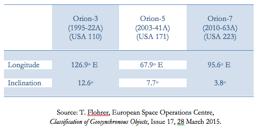
Figure 1. Pine Gap–controlled Orion SIGINT satellite stations, 2015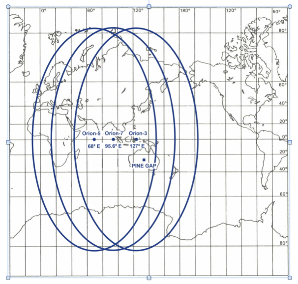
Pine Gap’s nine SIGINT satellites, 1970-2015
Nine geosynchronous SIGINT (signals intelligence) satellites have been operated by Pine Gap over the past 45 years. A 2-satellite constellation of Rhyolite and successor satellites was maintained from 1973 until 1995, followed by a 3-satellite constellation from 1995 to 2003 and a 4-satellite constellation from 2003 until the launch of Orion-7 in November 2010. With the arrival of Orion-7 the number of operational satellites may briefly have gone as high as five, but it quickly dropped again to three with the retirement of Orion-1 and Orion-2 in 2013.[2] Many of these satellites have exhibited amazing longevity. (See Tables 3 and 4.)
All of the National Reconnaissance Office’s (NRO’s) Orion-class geosynchronous SIGINT satellites since Orion-1 launched in January 1985 have been officially designated numerically, from Orion-1 to Orion-8, launched in June 2012.[3]
Rhyolite, the US government identifying codeword for the first of the Pine Gap signals intelligence satellites was changed to Aquacade after the Rhyolite program was made known to the Soviet Union by Christopher Boyce.[4] The first satellite of what became the Orion series was initially officially called Magnum-1, but, according to Richelson, by the time that satellite was launched from the Space Shuttle on 24 January 1985, the name had been changed to Orion-1.[5] The US government has retained the codename Orion for all geosynchronous SIGINT satellites controlled by Pine Gap launched since 1985. Some of the Orion satellites have had other codenames attributed to them at different stages through their development, such as Mentor and Advanced Orion. Many commentators have used the name Advanced Orion to refer to Orion-3 (also referred to as Mentor-1) and its successors, which aptly distinguishes them from their smaller and less capable predecessors.[6] (See Table 2 for a list of alternative satellite names.)
The nine geosynchronous SIGINT satellites that have been controlled from Pine Gap since 1970 in the Rhyolite, Aquacade and Orion series are listed in Table 3.
During the ground station site selection process in 1966, one of the main criteria was that the horizon angle from the floor of the selected location and over the surrounding hills ‘should not exceed six degrees’ (see Figure A.2).[7] From Pine Gap’s latitude of 23.80° S and longitude of 133.74° E, this would allow connectivity (for both command and control and for data reception) with satellites stationed as far west as 60° E (or as far east as 153° W if ever required). At any given time since 1973, one of the satellites controlled from Pine Gap has invariably been stationed at around 65-70° E longitude.
The first three Orion satellites were all operated from Pine Gap, but from the early 1990s the Orions were envisaged as a multi-purpose SIGINT satellite to succeed both the Central Intelligence Agency’s (CIA) Rhyolite/Aquacade system controlled from Pine Gap and the National Security Agency’s (NSA) similar Chalet/Vortex/Mercury system, controlled from Menwith Hill in Yorkshire, UK. Until around 1977-78, these were essentially autonomous programs, only loosely coordinated by the NRO (and then mainly with issues such as budget priorities and access to launch vehicles rather than the respective CIA and NSA SIGINT missions).
The major reorganisation of the NRO in 1997 established a SIGINT Directorate superimposed above the single Orion program, as well as collaborative operational, management and reporting processes at the Pine Gap and Menwith Hill stations. Orion-4, launched on 9 May 1998 and the first to be controlled from Menwith Hill, as well as Orion-6 launched on 19 January 2009 and also controlled from Menwith Hill, are evidently no different to Orion-3 or Orion-5 controlled from Pine Gap. There is now just one highly integrated US geosynchronous signals intelligence satellite system, with comparable satellites operated by Pine Gap and Menwith Hill, with much greater capacities and much more focussed military roles than their Cold War equivalents.
It does seem that Orion-7, launched on 21 November 2010 and controlled from Pine Gap, and certainly Orion-8, launched on 29 June 2012 and controlled from Menwith Hill, were each successively larger than their predecessors and have each carried more advanced capabilities.[8] However, this should not be regarded as reflecting any organisational or operational divergence within the program, but rather as involving the incorporation of evolving technological developments and responding to changing strategic priorities within a standard spacecraft design.
The full report is available here
III. References
[1] Satellites in geosychronous orbit (GEO) have an orbital period equal to one earth sidereal day (23 hours 56 minutes). Satellites in circular geosynchronous orbits that are aligned to the plane of the equator appear to an observer on the ground to sit in one place in space, and are called geostationary satellites. Those in geosynchronous orbits inclined with respect to the equatorial plane will typically appear to move in figure-of-eight patterns above and below fixed points on the equator each day, thereby allowing greater coverage of either or both of the two hemispheres. (See Appendix 2.)
[2] Names are assigned to satellites in a number of different and confusing ways. Some are systematic, and others idiosyncratic; some are official, others informal; some are public and some secret. All satellites today have an identification number issued by the Committee on Space Research (COSPAR) of the International Council for Science. COSPAR numbers identify the year the satellite was launched, its order amongst those launched in that year, and a letter indicating which payload, possibly among several on the same launcher. The satellite launched on 21 November 2010 has the COSPAR number 2010-63A, indicating it was placed into orbit following a launch in 2010 by a rocket which was the 63rd launch that year, and the SIGINT satellite was identified as the first payload from that launch. COSPAR numbers are sometimes shortened by omitting the first two numerals: e.g. 2010-63A becomes 10-63A. Orion-7 was also identified as NROL-32, indicating it is National Reconnaissance Office Launch-32, although not all NRO launches have been identified. It is also known by its unclassified US military name of USA 223. (See Tables 2 and 3.)
[3] ‘FY 2013 Congressional Budget Justification: Volume 1, National Intelligence Program Summary’, February 2012, p. 167.
[4] In the mid-1980s. other SIGINT satellite codenames were changed as they became compromised by becoming publicly known or thought to be known by adversary states. According to Jeffrey Richelson, this practice seems to have ended for SIGINT satellites in the late 1980s. Richelson notes that after he wrote about the Orion satellites, using that codename, in the second edition of his The US Intelligence Community, the name did not in fact change. (Letter from Jeffrey Richelson to the authors, 21 September 2015.)
[5] Jeffrey T. Richelson, The Wizards of Langley: Inside the CIA’s Directorate of Science and Technology, (Westview Press, Boulder, Colorado, 2001), p. 234.
[6] The Mentor and Advanced Orion ‘codenames’ are used in this paper where it seems appropriate to retain historical usage.
[7] ‘Cable dated 18 January 1966’, National Archives of Australia (NAA), ‘Joint Defence Space Research Facility: Policy 1965-1984’, Series A1945, Item 227/1/131.
[8] William Graham, ‘Delta IV Heavy Launches with NROL-32’, NASA Spaceflight.com, 21 November 2010, at http://www.nasaspaceflight.com/2010/11/live-delta-iv-heavy-launch-with-nrol-3/; and Jonathan McDowell, Jonathan’s Space Report, No. 661, 1 July 2012, at http://planet4589.org/space/jsr/back/news.661.