Introduction
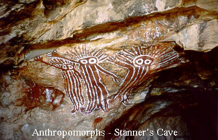
Anthropomorphs, Stanner’s Cave, Bradshaw Field Training Range
Source: Snapshots of Bradshaw Station – NT, Northern Territory Environment Protection Authority, at http://www.ntepa.nt.gov.au/environmental-assessments/assessment/register/bradshaw/snapshots
LocatioN:
Timber Creek, Victoria Highway, Northern Territory. 5°12’10″S 130°18’33″E Map: Bradshaw Field Training Area. National Heritage List. Bradshaw Field Training Area, Wikipedia Bradshaw Field Training Area, Wikimapia
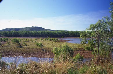
Victoria River, Bradshaw Field Training Range
Source: Australian Heritage Database
http://www.environment.gov.au/cgi-bin/heritage/photodb/imagesearch.pl?proc=detail;barcode_no=rt70949
According to a U.S. Army Corps of Engineers report
BFTA is a pastoral lease of some 8,700 km2 and is bounded to the north by the Fitzmaurice River and Wombungi Station, to the west by the Joseph Bonaparte Gulf, to the south by the Victoria River and to the east by Coolibah and Innesvale Stations (Figure 2). The property is approximately 150 km east to west and 70 km north to south. It consists of six major physiographic regions: hills and plain to the east (Eastern Hills), a large open plain (Angalarri Plain), a central plateau (Yambarran Plateau), a narrow valley (Koolendong Valley), dissected hills to the west (Western Hills), and a littoral zone which borders the ocean.
Government sources
Australia
Tindal offers ‘wow’ flying for visiting top guns, Lyndon Keane, Katherine Times, 22 October 2014
As part of Exercise Arnhem Thunder, about 140 members of No. 77 Squadron have converged on RAAF Base Tindal for three weeks of training, utilising the Delamere Air Weapons Range and the Bradshaw Field Training Area. “It’s basically our once-a-year bombing camp, so we use the Delamere range to the south-west of here, and Bradshaw out to the west, which are facilities we don’t have access to in Newcastle readily,” he told the Katherine Times.
“Williamtown is good, but it’s restrictive, and here is anything but restrictive. Where as here, you just take off and, wow, fantastic. It’s different here. The trees here are smaller, so when you low fly, you obviously see the trees rushing past and, because the trees are smaller, you can actually get too low, because you’re waiting for the same ground rush, but the trees aren’t as big.”
Talisman Sabre 2013, Final Public Environment Report, Aurecon Australia for Department of Defence, December 2012
Bradshaw Field Training Area covers approximately 871,000 ha and is located near Timber Creek, 600km by road south-west of Darwin in the Northern Territory. The training area is bound to the north by the Fitzmaurice River and Wombungi Station, to the west by the Joseph Bonaparte Gulf, by the Victoria River to the south, and to the east by pastoral properties.
The Bradshaw Field Training Area comprises an area of 870,000 ha, and is located near Timber Creek within the Victoria River region of the Northern Territory.
The Bradshaw Field Training Area is designed to support training in formation manoeuvre, field live firing and aerial livefiring and bombing. It includes field firing areas, high explosive impact areas, manoeuvre areas, training sectors and infrastructure to support management and operational use. Infrastructure at Bradshaw Field Training Area includes a limited road network, maintenance areas, a Range Control facility, a 500 person camp site and support facilities. External access to the Bradshaw Field Training Area is provided via a bridge across the Victoria River, approximately 8km west of Timber Creek and an access road from the Victoria Highway to the bridge. The bridge and roads are able to accommodate all ADF wheeled and tracked vehicles.
The Bradshaw Field Training Area has an internal road network of unsealed gravel two-lane formations, appropriate for all-weather use (although movement is generally restricted during the wet season to prevent damage to roads and tracks). The main internal road corridor is North Angalarri Road.
TS13 Potential Activities at Bradshaw Field Training Area
Air
− Flying aircraft including low-level (<1,000ft) and supersonic flights − Helicopter flying including low-level (<1,000ft), take off/landing and troop insertions − Use of aircraft radar − Use of lasers − Live firing of weapons (gunnery, missile and rocket firing, bombing) − Exercise logistics operations (e.g. loading/unloading, landing, parking, etc) − Air mobile operations − Air to air refuelling − Emergency dumping of fuels and jettisoning of stores (in emergency situations only)
Land
− Deployment of personnel/equipment by land/air − Live firing of weapons (infantry, artillery, mortars and armoured vehicles) − Military operations in urban terrain − Establishment and maintenance of target areas, gun positions − Logistics support (facilities, camp sites, infrastructure etc) − Construction and maintenance (roads, bridges, route clearance) − Detection and removal of unexploded ordnance (UXO) − Storage and movement of ammunition to the training area − Use of flares and pyrotechnics and battle noise simulation − Explosive obstacle clearing, road cratering and demolition practice − Defensive training against nuclear, biological and chemical warfare (does not include use of these weapons) − Putrescible / non-putrescible waste, sewerage and grew water collection, treatment and disposal − Establishment and operation of fuel farms, field workshops, field medical facilities, field power generation and distribution, fuel distribution
2004 Australia-United States Ministerial Consultation, Key Outcomes From Ausmin 2004: “Australia-US Joint Combined Training Centre:
- The agreement to develop a Joint Combined Training Centre will significantly enhance the quality of our bilateral training program and Australian Defence Force capabilities.
- Training facilities at the Shoalwater Bay Training Area in Queensland and the Bradshaw Training Area and Delamere Air Weapons Range in the Northern Territory will be further developed and linked with US facilities. The specific details of these upgrades are yet to be determined.
- The centre will not be a US base, and the United States has not proposed establishing a permanent base in Australia.”
$40.6 Million in Defence Funding for the Northern Territory, Minister for Defence, Brendan Nelson, Press Release, MIN73/06, 9 May 2006. Native Title and Land Rights – Challenges for Defence, Defence Magazine, June 2005.
Northern Territory
Bradshaw Field Training Area, Northern Territory Department of Resources, Environment and the Arts. Snapshots of Bradshaw Station – NT, Northern Territory Environment Protection Authority’ Bradshaw Field Training Area, Map of the Project Area Bradshaw Partnering Indigenous Land Use Agreement (ILUA) Map [Image]
United States
Project Description and Fact Sheet, Joint Rapid Airfield Construction (JRAC) 2007 Demonstration Project, Bradshaw Field Training Area (BFTA), Northern Territory, Australia, U.S. Army Corps of Engineers. Australian Airfield Site Surveys: Trip Report, U.S.Army Joint Rapid Airfield Construction (JRAC). FY 2007 Budget Item Justification Sheet, US Department of Defense February 2006. “Enhancing” the Australian-U.S. Defense Relationship: A Guide to U.S. Policy, Thomas-Durell Young, Strategic Studies Institute, U.S. Army War College, November 17, 1997.
As a result of the July 1996 Australian-U.S. Ministerial Meeting and the ADF’s shift to the north, new and old areas are being developed and/or considered for exercises by the ADF. However, just as there are a number of general limiting factors concerning exercises in Australia, so are there specific restrictions. One shared both by Bradshaw and Yampi Sound is that they are located within heavily used civil air corridors. Bradshaw Station. The former Bradshaw Station in the Northern Territory has recently been purchased by the Australian Department of Defence. It is approximately 600 kilometers from Darwin by road. Bradshaw’s mission will be to support 1st Brigade which is moving to Palmerston, NT from Holsworthy, NSW. The area comprises 1 million acres, is located between the Fitzmorris and Victoria rivers and is reputed to have good training terrain. The area has sea, air and land access. The ADF will have to upgrade existing infrastructure in the area (estimated to be $A50 million), and the Commonwealth will need to improve infrastructure leading to the area, which it has been slow to plan, according the Northern Territory government. Improvements include new sealed roads, simulation systems, construction/improvement of three airstrips which can operate C-130s, and three training camps similar to that being constructed at Mt. Bundi, southeast of Darwin. These improvements must be effected before the area can be used–current projections are that it will be ready in 1999. Of fundamental ADF concern regarding Bradshaw is that, despite its size, Bradshaw may not be sufficient for 1st Brigade’s training requirements. A key inhibiting factor is the area’s extreme environmental fragility. For example, it can take up to 10-years for the terrain to return to its normal state after it has been crossed by an armored tracked vehicle. As 1st Brigade is the test bed for new operational and organizational concepts which will affect the entire Army as outlined in “Army 21,” it is predictable that the area’s usage will be severely restricted to outside forces.
2013
MRF-D, MEU Marines partner with Aussies during Koolendong, Sarah Fiocco, DVIDS, 13 September 2013
Marines embark an MV-22B Osprey from the 31st Marine Expeditionary Unit during Exercise Koolendong at Bradshaw Field Training Area, Northern Territory, Australia Sept. 3. Marine Rotational Force–Darwin Marines traveled to the range either by foot, vehicle or aircraft. The training evolution involved Marines with MRF-D and the 31st MEU working bilaterally with Australian soldiers to assess the capacity of the training ranges to support a battalion-sized live-fire event. The Marines are with Company L, 3rd Battalion, 3rd Marine Regiment, MRF-D. 3rd Bn., 3rd Marines, and the 31st MEU are part of III Marine Expeditionary Force. The Australian soldiers are with Co. B, 5th Bn., Royal Australian Regiment.
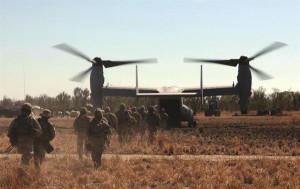
US Marines and Osprey, Exercise Koolendong, Bradshaw Field Training Range, September 2013
http://media.dma.mil/2013/Sep/13/2000711204/600/400/0/130904-M-AL626-976.JPG
Skids at the ready, all the time, Sgt. Paul Robbins, DVIDS, 3 September 2013 Integrated, live-fire assault proves viability of the outback, Cpl. Codey Underwood, DVIDS 4 September 2013
Marines and Sailors with Battalion Landing Team, 2nd Battalion, 4th Marines, 31st Marine Expeditionary Unit, along with Marine Rotational Force-Darwin and soldiers with 5th Royal Australian Regiment, conducted an integrated, live-fire training event as a part of Exercise Koolendong 13 The evolution included numerous ranges spread over thousands of square miles, allowing each company-sized unit to engage targets with live ammunition and achieve specific objectives. The coordinated assault utilized weaponry ranging from small arms weapons like rifle and machine guns, to artillery weapons from the 31st MEU’s battalion landing team, and close air support from helicopters of the 31st MEU’s aviation combat element. ”The training area gave us a chance to demonstrate our capabilities during one huge, live-fire exercise, combining all assets of a (Marine Air-Ground Task Force),” said Cpl. Andrew E. Jensen.
“This was a realistic scenario, showing we can hit a target with heavy force in an matter of hours.” Creating a plume of smoke and dust, the Expeditionary Fire Support System, a rifled-towed 120mm mortar, broke the silence with the first rounds on target. Their blasts were followed by the thunderous explosions of the M777A2 Lightweight Howitzer artillery, sending a barrage of shells. When the dust settled on the target area, MRF-D and Australian forces advanced on their softened targets. Days of coordination paved the way for smooth integration of the 31st MEU’s supporting fires and the advance of their adjacent units.
For the soldiers of the 5th RAR, the value of the training was more in the planning than the execution. “For ourselves, it’s the opportunity to extract ideas and continue to learn from each other,” said Australian Army Maj. Simon N. Croft, a 31-year-old company commander with Company B., 5th Royal Australian Regiment, 1st Brigade, and a native of Brisbane, Queensland, Australia. “There’s a lot of stuff we can learn in terms of logistics and maintaining ourselves in this type of training area.” Swinging around the edge of the MRF-D and Australian battle space, Light Armored Vehicle 25’s and armored High Mobility Multi-purpose Wheeled Vehicles cleared the way with M242 Bushmaster 25mm machine guns and Browning M2 .50 caliber machine guns.
Following the motorized assault, a platoon-sized Quick Reaction Force of Company E. Marines launched from the USS Bonhomme Richard (LHD 6) more than 90 miles away. The QRF arrived to the battlefield via MV-22 Ospreys from Marine Medium Tiltrotor Squadron (Reinforced) 265, 31st MEU, approximately twenty minutes after the call for reinforcements. Supported by M240G Medium machine guns from a position nearby and continuous fire by the Howitzers, the Marines quickly dispatched the notional enemy. The battalion-sized assault successfully implemented multiple units and numerous weapons systems, demonstrating the potential of the training area for both unilateral and bilateral live-fire operations in the future.
“(Bradshaw Field Training Area) offers both U.S. and Australian units a unique opportunity in the Pacific to train high-end, combined-arms live-fire. We were able to employ all arms of the MAGTF and work with our Australian counterparts under demanding natural conditions,” said Lt. Col. John G. Lehane, the 38-year-old operations officer with the 31st MEU and native of West Hempsted, N.Y. “We have used a relatively small portion of the training area and have only scratched the surface of what could be possible here.” The 31st MEU moved a battalion-sized force more than 300 miles inland to conduct Exercise Koolendong 13. The exercise demonstrates the operational reach of the 31st MEU and reinforces why the 31st MEU is the force of choice for the Asia-Pacific region. Also participating in the exercise is the Marine Rotational Force – Darwin and soldiers of the 5th Royal Australian Army. The 31st MEU brings what it needs to sustain itself to accomplish the mission or to pave the way for follow-on forces.
Analysis
Joint Rapid Airfield Construction Project, Bradshaw Field Training Area, Timber Creek, NT, Australia, Living Moon .com Bradshaw Field Training Area Community Baseline and Social Impact Assessment, Research Institute for the Environment and Livelihoods, Charles Darwin University Researchers to study military impact on Bradshaw, Patrick Nelson, e-news, Charles Darwin University, Issue 11, 6 December 2011
CDU’s Research Institute for the Environment and Livelihoods (RIEL) has been contracted to study the effects of military training at the Bradshaw Field Training Area near Timber Creek. The Department of Defence has commissioned a multidisciplinary team of researchers including Professor Owen Stanley (Indigenous economic development), Hmalan Hunter-Xenie (Indigenous engagement) and Dr Natasha Stacey (anthropologist), of RIEL, and Associate Professor Andrew McWilliam (anthropologist) from ANU, to undertake the research.
They will conduct a social impact assessment review and a baseline community assessment of the Indigenous Land Use Agreement (for Bradshaw), work out ways to increase benefits and minimise potential risks, and develop monitoring and business plans. Stakeholders will be interviewed and fieldwork will be undertaken in Timber Creek, Katherine, Kununurra, Wadeye, Peppimenarti, Nganmarriyanga and other locations where the Bradshaw Traditional Owners now live. The project will be overseen by the Bradshaw Liaison Committee, comprising representatives from Traditional Owners, the Northern Land Council and the Department of Defence.
Wide open spaces attract training bases, The Age 8 July 2004
Australia has one thing the United States lacks when it comes to training its forces in the Asia-Pacific region – lots of wide open space. US forces based on heavily populated Okinawa and Japan simply lack the space for large scale manoeuvers. Political sensitivities limit the extent of realistic training on the Korean Peninsular. In contrast, the three Australian training areas slated for upgrade for joint Australia-US training are simply vast. The principal site for the proposed joint training, the Shoalwater Bay Training Area in northern Queensland, covers 270,000 hectares on land and 180,000 hectares at sea. It’s the only area in Australia where the navy, army and airforce can engage in joint exercises, including those with international forces. The Bradshaw Field Training Area in the Northern Territory covers more than 870,000 hectares. The Delamere Air Weapons Range, also in the Northern Territory, covers 211,000 hectares. It’s regarded as one of only a few air weapons ranges in the world able to accommodate training with all conventional weapons.
The Singaporean defence force keeps a warehouse full of tanks and armoured personnel carriers at Rockhampton which it uses for training on Shoalwater Bay.
Project coordinator: Richard Tanter
Updated: 28 October 2014