|
Expedition 3: What’s in a Watershed?
We all live in a watershed. Part of the hydrological cycle, a watershed represents the portion of a landscape that drains to a particular stream, river or other body of water. In this activity you research and map the watersheds that drain into Tokyo Bay and San Francisco Bay.
 1. Gather mapping tools for the activity: a world atlas, regional maps, a globe, satellite or space shuttle images.
2. Identify relevant maps using the links provided below and respond to the following questions, (additional mapping tools may be helpful).
Environmental Protection Agency
Surf your watershed! Locate watershed by using state maps, zip codes, or stream names.
Tokyo Bay
San Francisco Bay
Bay Area Watershed Maps: Past and Present
San Francisco Bay Area EcoAtlas
The Bay Area EcoAtlas presents detailed regional views of past and present.CERES
Maps, spatial data, and photos, San Francisco CountyCalifornia Interactive Maps
Map of the San Francisco Bay Area
3. Describe the major watershed systems of the Bay region you are studying. What rivers, lakes, and deltas are visible?
____________________________________________
4. Where do the rivers originate? What mountain ranges and hills surround the watershed? What is the highest point of elevation in the watershed?
____________________________________________
____________________________________________
5. What major cities occupy the watershed region?
____________________________________________
____________________________________________
6. Create a map of the watershed.
a. In pencil, sketch the outlines of the Bay watershed. Include mountains, rivers, major creeks, lakes, and the Bay itself.
b. Determine which direction is north, and draw a compass rose in the southeast corner of your sketch.
c. Estimate the scale of the map in miles (or kilometers). Add a scale next to your compass rose.
d. Add geographical features of relevance: major cities, dams and reservoirs, wetlands, the highest point of elevation.
After completing your sketch, take time to clean up the map and highlight features of interest. Add color and symbols to enhance a reader’s understanding.
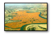
Complete the activity by writing a short narrative describing the image from space. Call attention to some of the features you have labeled on your map and explain their significance.
 Links
Links
Tokyo Bay
Boat Trip Down the Sumida River
Photo essay journaling an adventure down the Sumida River through Metropolitan Tokyo, May 1997.
San Francisco Bay
Environmental Planning and Geographic Information Systems, University of California
Aerial photography and maps of the San Francisco Bay and Delta, and aerial photographs depicting issues in land use and environmental planning around the SF Bay and Delta.
San Francisco Estuary Institute
A photographic presentation on the Bay Area’s watershed, wetland ecology and development during periods of heavy precipitation.
US Geological Survey
Information about the San Francisco Bay’s wetlands, including satellite images of the Bay and Delta.