Introduction
Australian navy and visiting foreign navy ships normally berth at Fort Hill Wharf or occasionally at East Arm Wharf.
See also
- US ship visits to Darwin
- Log of US Navy ship visits to Darwin, 2000 – 2014 (updated 1 April 2014)
LOCATION:
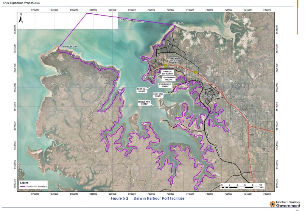
Fort Hill Wharf: 12°28’18″S 130°50’44″E
East Arm Wharf: 12°29′S 130°52′E
Port of Darwin, Fact Sheet No.1, Darwin Port Corporation
The Port of Darwin, located at latitude 12° 28’S, longitude 130° 50’E, on the southern shore ofthe Beagle Gulf in the Timor Sea, encompasses approximately 1,000km2 of open water, with deep shipping channels. A line between Charles Point and Lee Point defines the seaward boundary of the port.
A naturally occurring deep water port with world class facilities and services, the Port of Darwin is strategically positioned at the ‘top end’ of Australia, making it the closest port to SE Asia and ‘Australia’s northern gateway of choice’.
A multi-modal hub, the Port comprises Stokes Hill Wharf, Fort Hill Wharf, Frances Bay Marina, Fisherman’s Wharf and East Arm Wharf which is located 13.5kms by road from the Darwin CBD and is the Port’s main working facility. It has both road and rail access and utilises modern materials handling equipment to efficiently move 4,577,000 tonnes of cargo annually.
Vessels drawing 11m can enter the Port in all tidal conditions. Drafts over 11m may be accepted with prior consultation and may need to wait for appropriate tidal conditions before entering the harbour. Vessels up to 246 LOA and 12.83m draft have been accepted to the port.Middle Pass, the channel through Charles Point Patches at the entrance to Darwin Harbour has a depth of 12.2m.
Project coordinator: Richard Tanter
Updated: 1 April 2014